| View Public Meeting #1 Materials |
| View Public Meeting #2 Materials |
| View Public Meeting #3 Materials |
| View Public Input Opportunity Materials |
PUBLIC INPUT OPPORTUNITY
The Public Input Opportunity was held virtually from September 28, 2020 to November 9, 2020 through the interactive website NLSDinput.org. View the Public Input Opportunity brochure here.
During this time, participants could review updates to the proposed designs and alternatives through project videos and exhibits. Participants were also encouraged to provide input through an interactive mapping tool, an ideas wall, a public survey, the comment web portal, and the project email.
The project team also held small group discussions on October 13, 2020 and October 14, 2020 which provided participants the opportunity to provide feedback directly to the project team. The official comment period for the Public Input Opportunity ended on November 9, 2020.
To learn more about the Public Input Opportunity, including feedback heard from the public and next steps for the project, please check out the Winter 2021 Newsletter.
PUBLIC INPUT OPPORTUNITY SURVEY RESULTS
An online survey was available throughout the Public Input Opportunity in order to receive input and feedback regarding participants’ usage of the corridor and priorities for the Alternatives to be Carried Forward (ATBCF). The survey was accessible online through November 9, 2020. In total 3,257 surveys were completed. Survey highlights are included below, along with the complete survey results.
SURVEY HIGHLIGHTS
-
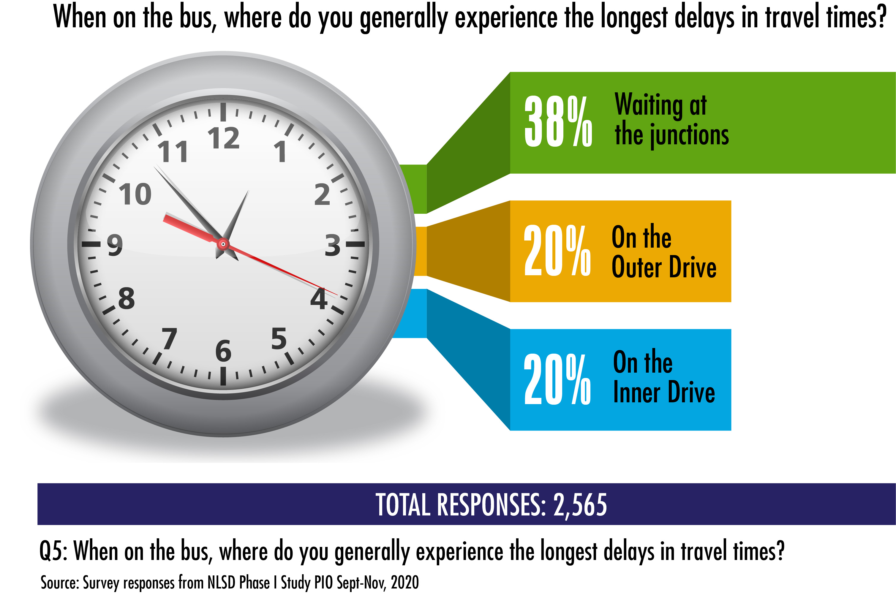
Experiencing delays on the bus
-
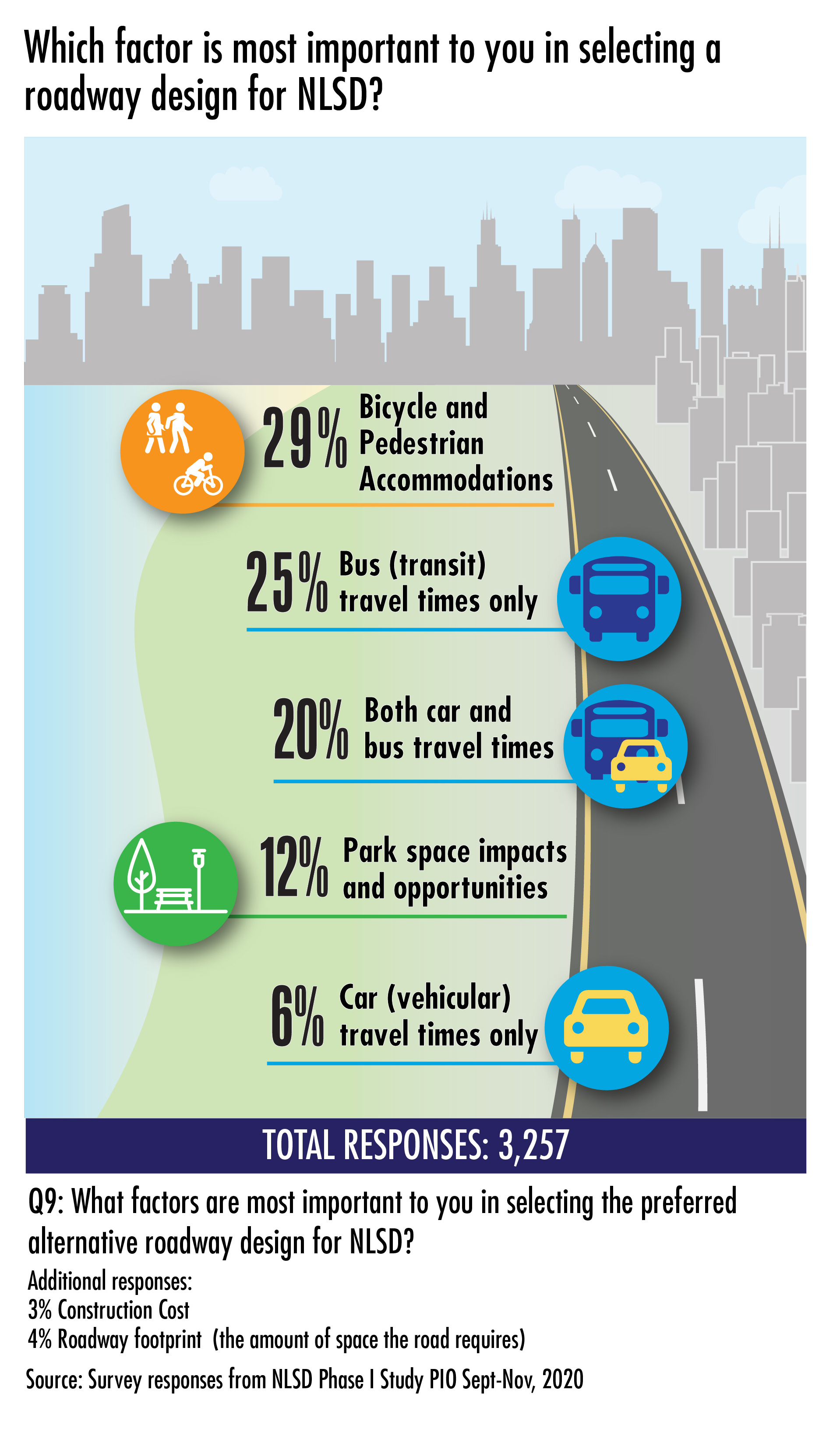
Factors for supporting an alternative
-
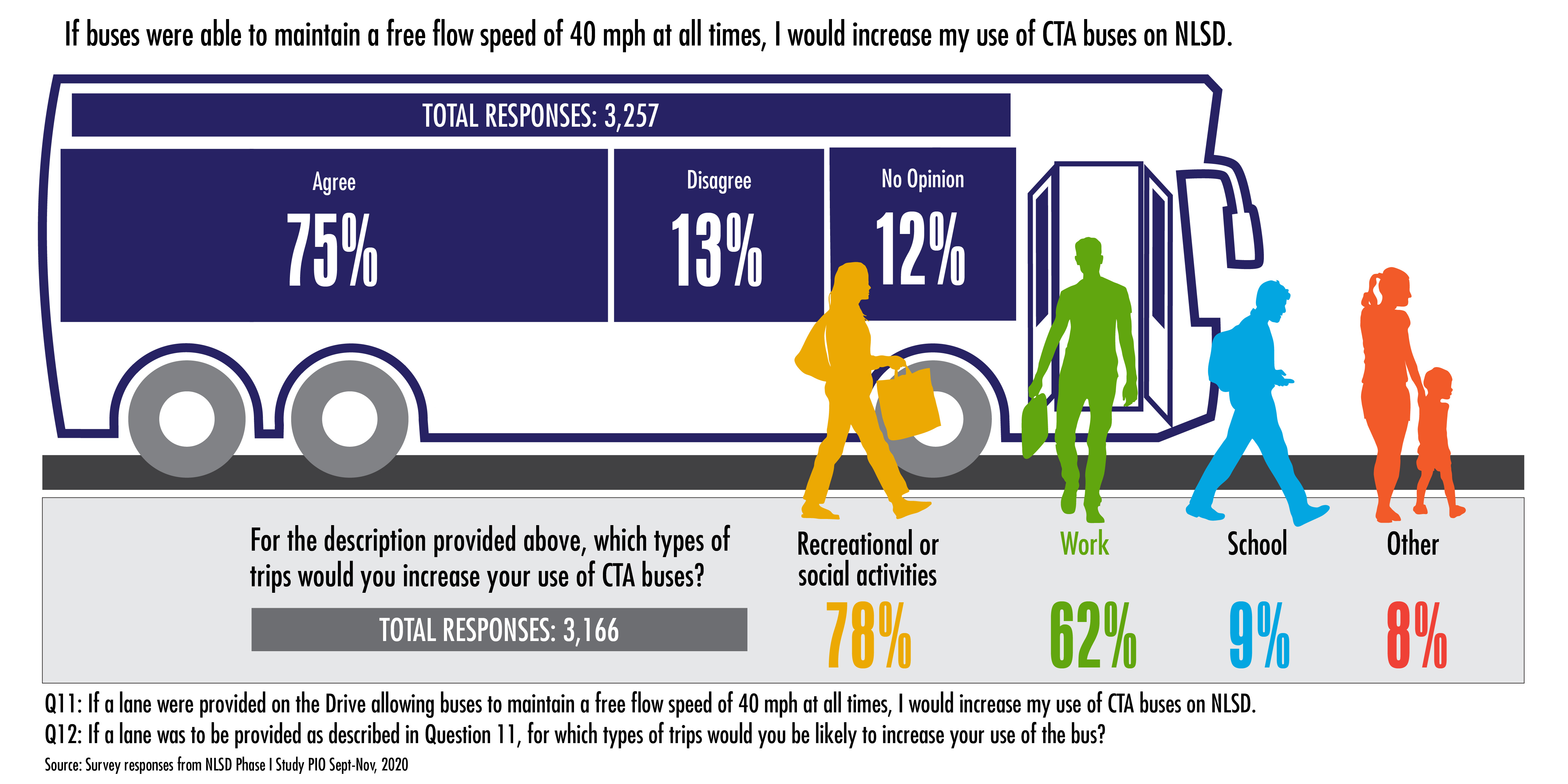
How would you use the bus?
-
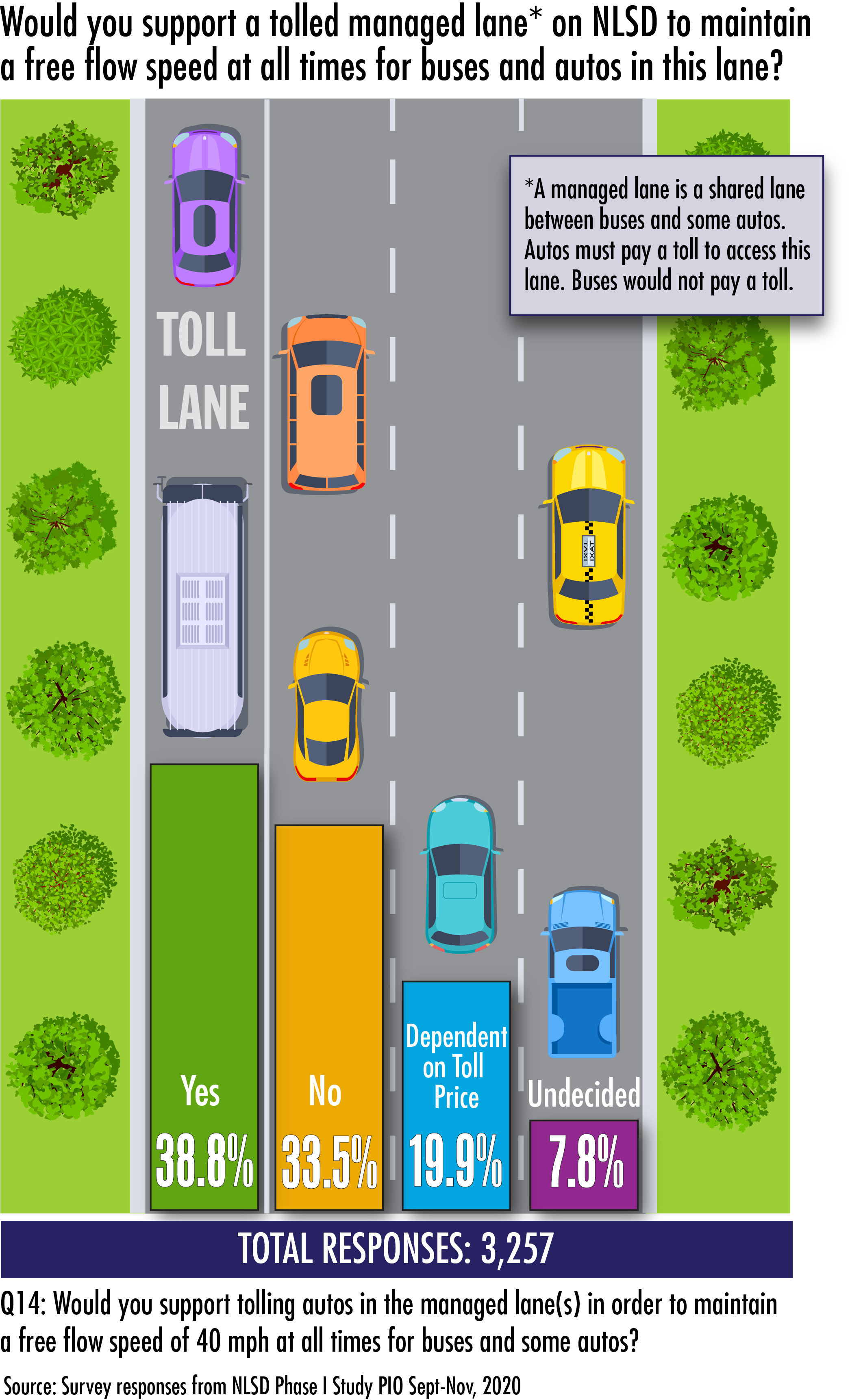
Supporting tolling a Manged Lane
-
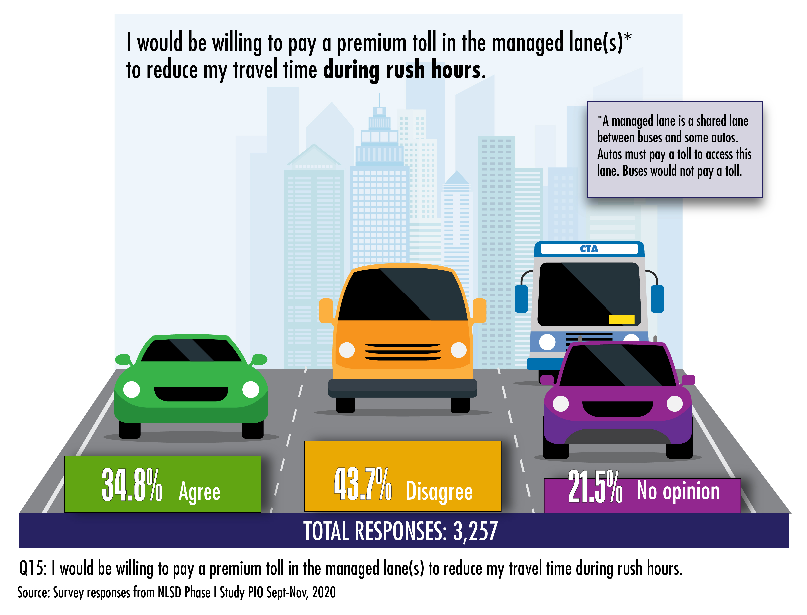
Would you pay a toll to use the Managed Lane?
Complete Survey Results (PDF)
PUBLIC INPUT OPPORTUNITY INTERACTIVE MAP RESULTS
An interactive map was available throughout the Public Input Opportunity in order to collect and share thoughts from the public about the proposed improvements. Through this tool, participants were able to like, dislike, or comment on proposed designs in specific locations throughout the study area. To view the most remarked upon locations, based on number of likes, dislikes and comments, view the Popular Comment Maps below. Please note, the Essential alternative has been used as a base map for ease of review, but the corresponding statistics reflect input that may have been provided regarding any alternative in that area. You may also access all of the detailed input and feedback received from the interactive maps by clicking here.
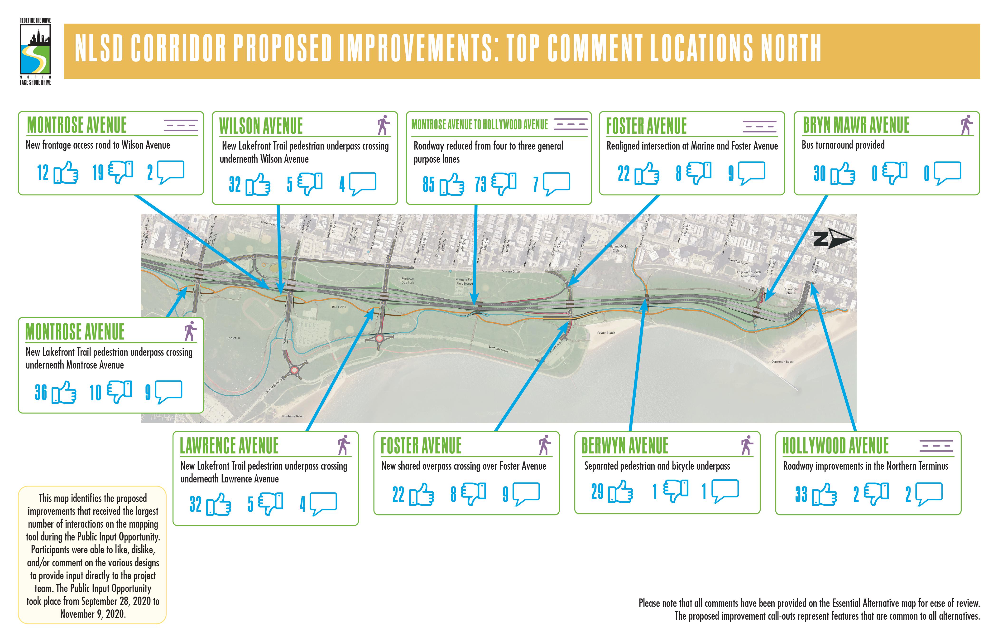 POPULAR COMMENT MAP FOR THE NORTHERN CORRIDOR (PDF)
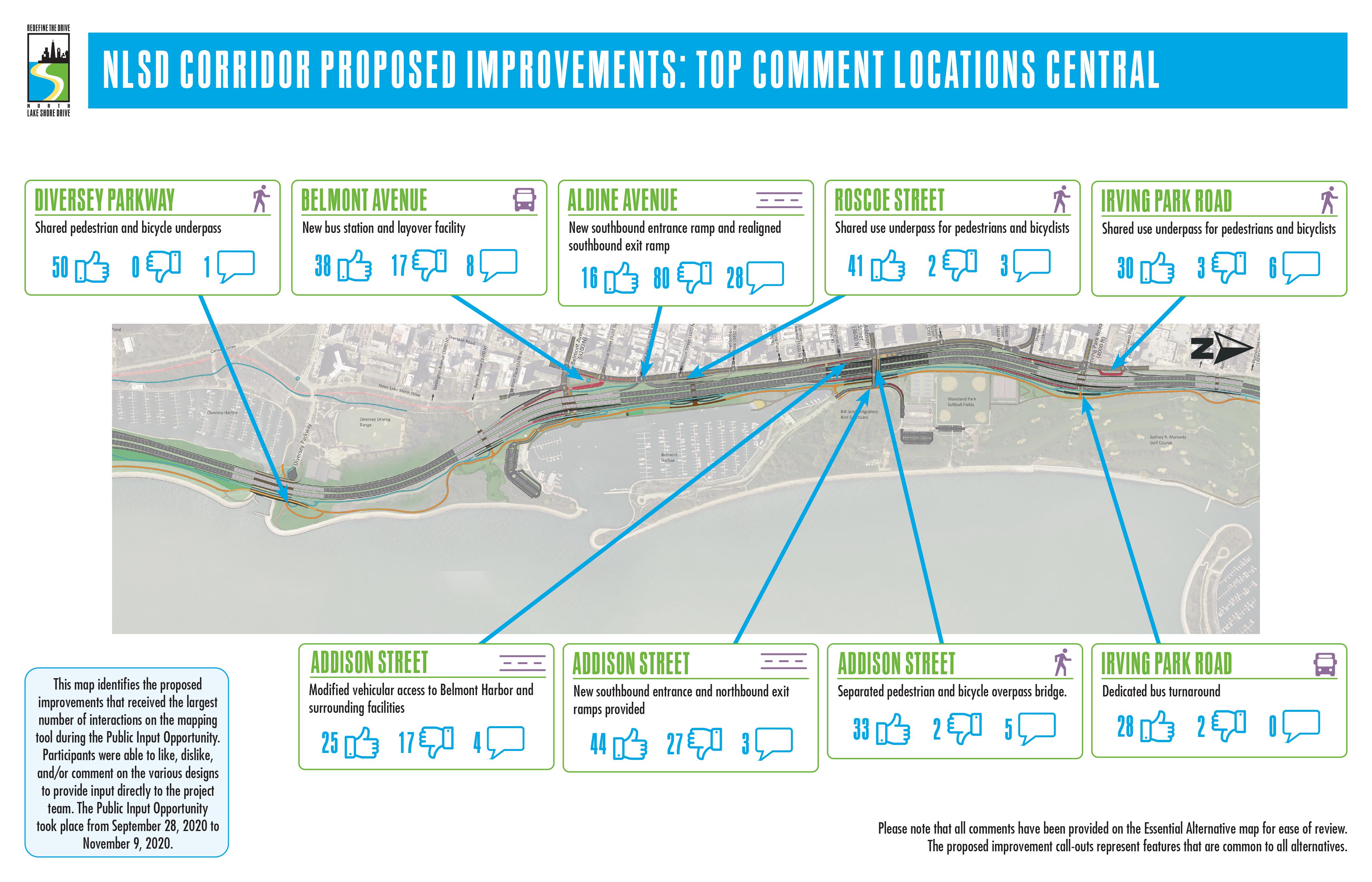 POPULAR COMMENT MAP FOR THE CENTRAL CORRIDOR
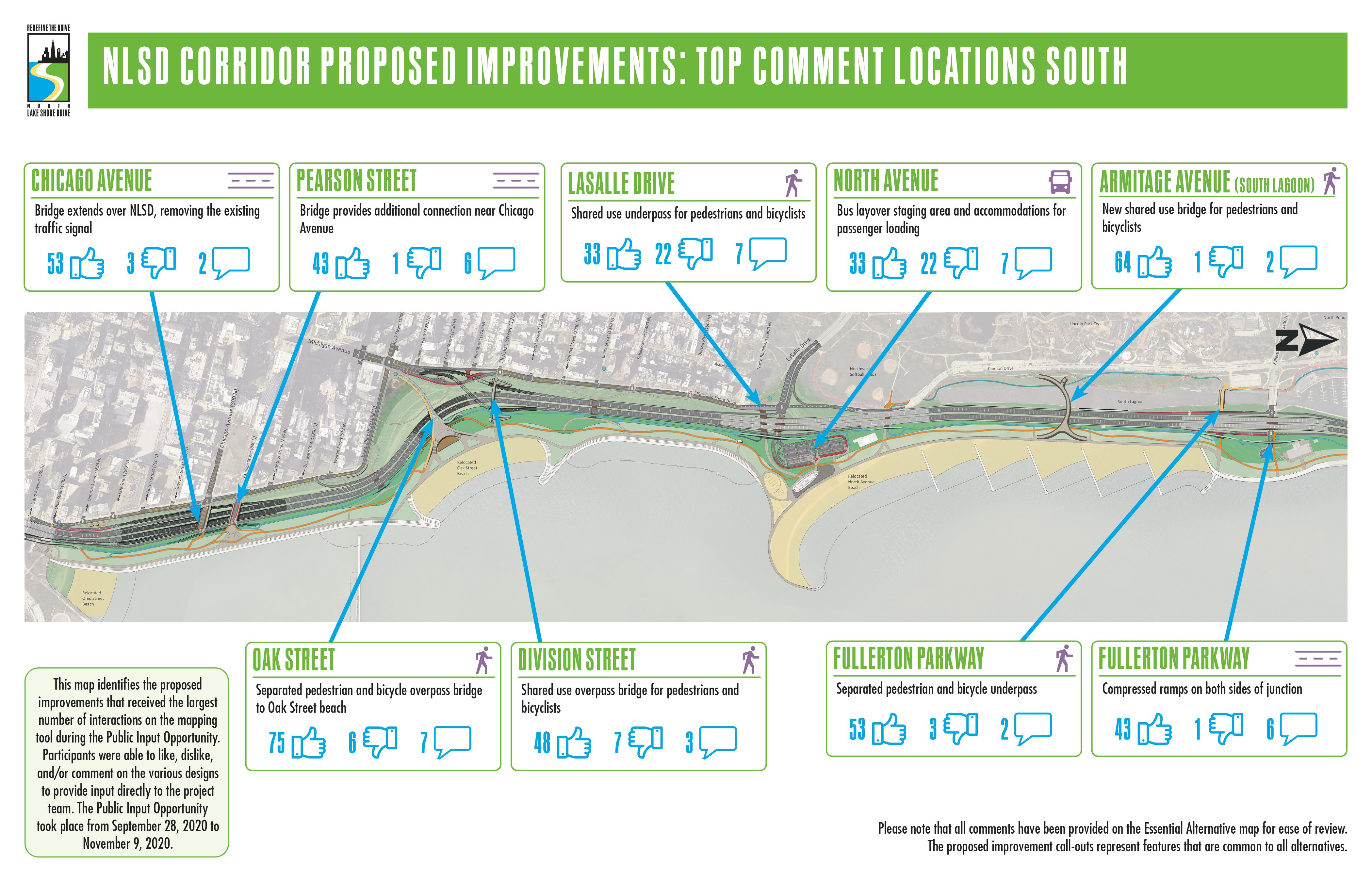 POPULAR COMMENT MAP FOR THE SOUTHERN CORRIDOR
PUBLIC INPUT OPPORTUNITY IDEAS WALL
During the meeting, an ideas wall was provided to allow participants to share their ideas on existing issues and the proposed improvements in the North DuSable Lake Shore Drive study area. On the ideas wall, participants were able provide original comments as well as respond to others’ input. You may access all of the input and feedback received from the ideas wall by clicking here.
PUBLIC INPUT OPPORTUNITY SMALL GROUP DISCUSSIONS
To make up for the one-on-one interaction that typically occurs during in-person Public Meetings, the Public Input Opportunity also included small group discussions as an outlet for the public to provide questions or comments directly to the project team in real time. Participants signed up to review the project with the project team via Zoom or a call-in option. These discussions were held on October 13, 2020 and October 14, 2020. A total of 75 participants attended seven sessions. To learn more about what was discussed during the small group discussions, check out the summary below.
Small Group Discussion Common Questions and Responses Summary (PDF)
PROJECT UPDATE VIDEOS
Study Background
This presentation briefly reviews the goals of the NDLSD Phase I Study, the public involvement that has taken place during the study, and the policies and guidelines the study follows.
Common Improvements to All Alternatives
This presentation examines the proposed designs that are included in all NDLSD alternatives, including improvements to transit, the Lakefront Trail, the parks, the roadway, and the shoreline.
Alternatives Screening Results to Date & Next Steps
This presentation provides a high-level overview of the alternatives that were analyzed during Level 2 Screening and the results of the evaluation. A preview of the Level 3 Screening process and the study’s next steps are also included.
SUPPLEMENTAL VIDEOS
Phase I Study
This presentation provides a review of the Phase I Study, including background information on the project process, the identified corridor transportation needs, the categories of potential alternatives, and the alternatives evaluation process.
Alternatives Evaluation
The Alternatives Evaluation Review provides a detailed look into the diverse group of roadway design improvements that were analyzed, how those alternatives were evaluated, the results of the Level 1 and Level 2 alternatives evaluation process, and a preview of the Level 3 Screening process
PUBLIC SURVEY (click here to view)
PROJECT EXHIBITS
STUDY SPOTLIGHTS
- Purpose & Need and Public Involvement
- Lakefront Trail and Park Access
- Environment and Climate Change
- Transit Improvements
CORRIDOR VISUALIZATIONS (NORTH)
CORRIDOR VISUALIZATIONS (CENTRAL)
CORRIDOR VISUALIZATIONS (SOUTH)
- Chicago Avenue
- Fullerton Avenue Bridge
- Oak Street Beach (looking north)
- Oak Street (looking southeast)
CORRIDOR VISUALIZATIONS (TYPICAL SECTIONS)
LEVEL 2 SCREENING DOCUMENTS
- Level 2 Screening Table
- Level 2 Screening Results - Transitway Alternatives
- Level 2 Screening Results - Managed Lane Alternatives
PROPOSED DESIGNS FOR THE FIVE ALTERNATIVES TO BE CARRIED FORWARD TO LEVEL 3 SCREENING:
"THE ESSENTIAL"
Transit Priority – Junctions
(Context Tailored Treatments With Transit Advantages – CTT+TA)
- Typical Cross Section
- North CTT+TA Plans (Montrose Ave. to Hollywood Ave.)
- Central CTT+TA Plans (Diversey Pkwy. to Montrose Ave.)
- South CTT+TA Plans (Grand Ave. to Diversey Pkwy.)
"THE ADDITION"
Transit Priority – Exclusive
(Dedicated Transitway-Left – DTW-L)
- Typical Cross Section
- North DTW-L Plans (Montrose Ave. to Hollywood Ave.)
- Central DTW-L Plans (Diversey Pkwy. to Montrose Ave.)
- South DTW-L Plans (Grand Ave. to Diversey Pkwy.)
"THE EXCHANGE"
Transit Priority – Exclusive
(3+1 Bus Only Lane – 3+1 BOL)
- Typical Cross Section
- North 3+1 BOL Plans (Montrose Ave. to Hollywood Ave.)
- Central 3+1 BOL Plans (Diversey Pkwy. to Montrose Ave.)
- South 3+1 BOL Plans (Grand Ave. to Diversey Pkwy.)
"THE FLEX"
Transit Priority – Shared
(3+1 Managed Lane – 3+1 ML)
- Typical Cross Section
- North 3+1 ML Plans (Montrose Ave. to Hollywood Ave.)
- Central 3+1 ML Plans (Diversey Pkwy. to Montrose Ave.)
- South 3+1 ML Plans (Grand Ave. to Diversey Pkwy.)
"THE DOUBLE FLEX"
Transit Priority – Shared
(2+2 Managed Lanes – 2+2 ML)
- Typical Cross Section
- North 2+2 ML Plans (Montrose Ave. to Hollywood Ave.)
- Central 2+2 ML Plans (Diversey Pkwy. to Montrose Ave.)
- South 2+2 ML Plans (Grand Ave. to Diversey Pkwy.)
ADDITIONAL PLANS AND INFORMATION COMMON TO ALL ALTERNATIVES:
SHORELINE PROTECTION
NORTHERN TERMINUS TRAFFIC STUDY
STUDY BACKGROUND
EXISTING CONDITIONS
- Average Daily Traffic
- Crash Data
- Infrastructure Report Card
- Lakefront Trail Ridership
- Transit Ridership